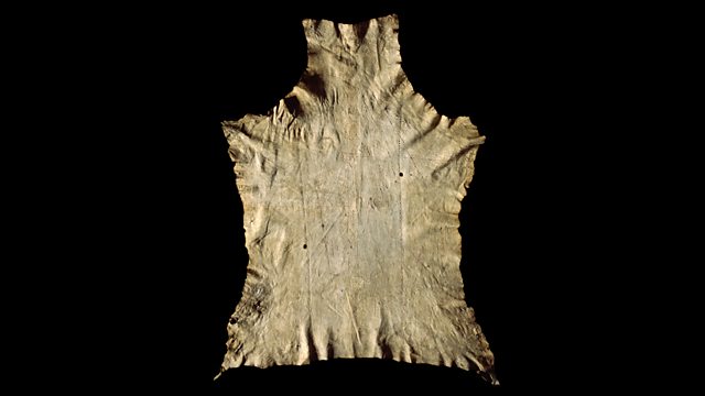
North American Buckskin Map
Neil MacGregor's history of the world is exploring European engagement with the rest of the world in the 18th century. Today, he is with a buckskin map from North America.
The history of humanity - as told through one hundred objects from the British Museum in London - is once again in North America. This week, Neil MacGregor, the museum's director, is looking at Europe's engagement with the rest of the world in the 18th century.
Today he tells the story of a map, roughly drawn on deerskin that was used as the colonists negotiated for land in the area between the Great Lakes and the Mississippi. It was probably drawn up by a Native American around 1774. Neil looks at how the French and the British were in conflict in the region, and examines the different attitudes to land and living between Europeans and Native Americans. Martin Lewis, an expert on maps from this region, and the historian David Edmunds describe the map and the clash of cultures that was played out within its boundaries.
Producer: Anthony Denselow
Last on
![]()
A History of the World in 100 Objects - objects related to money, trade and travel.

About this object
Location: Midwestern USA
Culture: Native North America
Period: 1774-5
Material: Animal Material
��
This buckskin map depicts a vast area of the American Midwest between the Mississippi and Ohio rivers. It was probably drawn by Piankshaw Indians and the red circles and semi-circles represent Native American settlement Native American maps are conceptual different than those of European settlers, containing more symbolic elements and reflecting different notions of space and time. Rivers were vitally important to Native Americans and the Wabash River runs along the spine of the deerskin, following the animal's life force.
Why was the map created?
Written phrases, like 'Piankashaw sold', on the lower right hand side of the map, suggest it was used as an intermediary tool to communicate between Europeans and Native Americans. It was probably created to aid negotiations during an attempt by the Wabash Land Company to purchase territory from the Piankashaw Indians in 1774 - 5. As European trappers and traders expanded west, private companies sought to purchase land from Native American nations. Such negotiations ignored the existing treaties with Native American people and this sale of land was declared void by the British colonial government.
Did you know?
- This map was once part of a collection of Native American objects at Stonyhurst College, a Jesuit school in Lancashire.
Cross-cultural map for a changing world
By Devorah Romanek, curator, British Museum
��
This map was made by an Algonquian speaking group of Native North Americans of the Ohio River Valley area around the 1770s, most likely the Piankashaw. The Piankashaw were one of the six constituent groups of the Miami people, but became independent of them around 1700. Some decade after the making of this map the Piankashaw merged with other Miami-Illinois related groups, the Wea and Kaskaskia, to become the Peoria.
The map is drawn on deer hide, which was prepared through a process known as brain tanning. This process consists of removing the hide from the animal, cleaning the hide (e.g., soaking, racking and fleshing) and then treating the surface by rubbing a mixture of various things over the surface of the hide, this mixture typically including the brain of the animal, grease, bone marrow, liver and other plant materials. In this way, the hide becomes saturated with collagen from the brain and the other materials creating a semi-tanned hide.
The lines, markings and words drawn on the map were made using commonly available commercial inks - red (vermillion) and black (carbon) – and not native pigments and mordants.
The use of this ink, in combination with the inclusion of the use of European (English) language words on the map, and the overall context of time and place where the map was made indicate that this map was created as a collaboration and/or negotiation – a land transaction - between the indigenous Miami people and Europeans.
In such a transaction it is likely that land was purchased by Europeans in return for trade goods. This transaction also would have taken place in a time of great political tumult and contention , with the recent end of the Seven Years War. This was also a time when English law actually forbade land sales and purchases west of the Allegany’s, and such a land sale would not have been legal, though entrepreneurs making such deals tried unsuccessfully to find complicated ways around these laws..
While the European handwritten words, as well as perhaps the use of commercial inks, indicate the participation of Europeans in making this map, the conventions are Native American. The lines and symbols on the map are drawn in a symbolic and cosmological manner, as opposed to topographically. The Wabash River, drawn down the middle of the hide, is not rendered literally, but rather follows the spine of the deer, mapped out following the life force of the animal as an indication that this river would have been the life force of the people who drew this map.
The other rivers are also represented symbolically, and in a manner reflecting the time it would take to travel on rivers from each village marked out on the map, rather than the actual space. Additionally, there are 14 Native villages on this map, at a time when only two of these 14 are to be found on European maps – and very notably, St Louis is not depicted on this map, though it falls within the topographic area covered.
The combination of all of these things on the map reflects native perspective, European contribution, and is a product of cross-cultural negotiation in a world that was changing rapidly.
Transcript
Broadcasts
 Wed 6 Oct 2010 09:45������̳ Radio 4 FM
- Wed 6 Oct 2010 19:45������̳ Radio 4
- Thu 7 Oct 2010 00:30������̳ Radio 4
- Wed 15 Sep 2021 13:45������̳ Radio 4
Featured in...
![]()
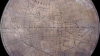
Mapping the World
A collection of programmes relating to maps.
![]()
Money, Trade and Travel—A History of the World in 100 Objects
A History of the World in 100 Objects - objects related to money, trade and travel.

Shakespeare's Restless World
Neil MacGregor uncovers Shakespeare's world through twenty objects.
Podcast
-
![]()
A History of the World in 100 Objects
Director of the British Museum, Neil MacGregor, retells humanity's history through objects
