
The recent cold spell is the coldest we've had for about two years! Last Sunday night into Monday the temperature in Tirabad in Powys dropped to almost -8°C.
There's been some snow too, most of it on high ground. Last night about 10cm (4") of fresh snow fell on the Berwyn Mountains in Denbighshire.
Snow was forecast for some other parts of Wales on Tuesday night and on Wednesday. But in Blaenau Gwent mostly rain fell due to a slight rise in temperature in the area. and a small change in temperature can make all the difference between rain and snow.
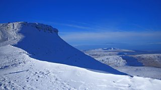
Corn Du covered in snow by Colin Harvey
Looking ahead, the cold spell is on its last legs with a change on the way tomorrow. However, a widespread frost is expected tonight with lowest temperatures typically around -3°C. Where there is any lying snow, the temperature could fall as low as -7°C with a few freezing fog patches. The coast will be less cold with St Davids and Holyhead staying above freezing.
Friday will start dry with some sunshine but rain will reach Anglesey before midday and then spread south-east across the rest of the country during the afternoon with most of the rain in the south and west. The wind will pick up and it will turn milder with temperatures rising to between 5 and 10°C. During the night the rain will clear and it will turn colder again with a slight frost inland.
Saturday will be the best day of the weekend. There may be the odd shower in the north first thing, otherwise it will be dry, bright and breezy with sunshine and good visibility. Top temperatures will reach 5 to 7°C with a north-westerly breeze.
Saturday night will be dry with a slight frost inland. On Sunday cloud will increase, bringing spots of rain and drizzle. The north-east and the Marches will be drier. It will turn milder again on Sunday with a south-westerly breeze with highs reaching between 8 and 10°C.
Next week will bring changeable weather; rain on Monday will clear and it will turn colder again. Tuesday should be dry and chilly. From mid-week onwards it looks much more unsettled, with spells of rain and a risk of severe gales. Temperatures will vary with a risk of snow in the north, especially on high ground and there is a possibility it may turn colder by next weekend with winds from the Arctic.